The First Settlers
The first settlers reached Peru some 20.000
years ago. They brought stone tools and were hunter-gatherers, living off game and fruit. Some of them settled in Paccaicasa,
Ayacucho. The most ancient Peruvian skeletal remains found to date (7.000 BC) show the ancient
settlers to have had broad faces, pointed heads and to stand 1.60 meters tall. The early Peruvians left examples of cave paintings
at Toquepala (Tacna, 7.600 BC) and houses in Chilca (Lima, 5.800 BC).
The process of domesticating plants was to lay the foundations for organized
agriculture and the construction of villages and ceremonial sites. As the regional cultures gradually integrated, new techniques
surfaced such as textile weaving, metallurgy and jewelsmithy, giving rise to advanced cultures.
The Pre-Incas Cultures
Over the course of 1.400 years, pre-Inca cultures settled along the Peruvian
coast and highlands. The power and influence of some civilizations was to hold sway over large swaths of territory, which
during their decline, gave way to minor regional centers. Many of them stood out for their ritual pottery, their ability to
adapt and superb management of their natural resources; a vast knowledge from which later the Inca empire was to draw.
Chavin
The first Peruvian civilization settled in Huantar, Ancash in around 1.000 BC. The power of the civilization, based on a
theocracy, was centered in the Chavin de Huantar
temple, whose walls and galleries were filled with sculptures of ferocious deities with feline features
Paracas
The Paracas
culture (700 BC) rose to power along the south coast, and was to craft
superb skills in textile weaving
Mochicas
The north coast was dominated by the Mochica civilization (100 AD). The culture gathered together military authorities in the coastal
valleys, such as the Lord of Sipan. The Moche pots which featured portraits, and their iconography in general were surprisingly
detailed and showed great skill in design
Tiahuanaco
The highlands saw the rise of the Tiahuanaco culture (200 AD), based in the Collao region (which covered parts of modern-day
Bolivia and Chile). The Tiahuanaco were to bequeath a legacy of agricultural terracing and the management of a variety of
ecological zones
Nazca
The Nazca
culture (300 AD) were able to tme the coastal desert by bringing water through underground aqueducts. They carved
out vast geometric and animal figures on the desert floor, a series of symbols believed to form part of an agricultural calendar
which even today baffles researchers.
Wari
The
Wari culture (600 AD) introduced urban settlements in the Ayacucho area and expanded
its influence across the Andes
Chimu
The refined Chimu culture (700 AD) crafted gold and other metals into relics and built the mud-brick citadel of Chan
Chan, near the northern coastal city of Trujillo
Chachapoyas
The Chachapoyas
culture (800 AD) made the best possible use of arable land and built their constructions on top of the highest
mountains in the northern cloud forest. The vast Kuelap fortress is a fine example of how they adapted to their environment
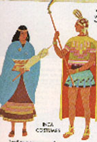
The Incas Empire
The Inca empire
(1.500 AD) was possibly the most organized civilization in South America. Their economic system, distribution of wealth, artistic
manifestations and architecture impressed the first of the Spanish chroniclers
The Incas worshipped the earth goddess Pachamama and the sun god, the Inti. The Inca sovereign, lord of the Tahuantinsuyo,
the Inca empire, was held to be sacred and to be the descendant of the sun god. Thus, the legend of the origin of the Incas
tells how the sun god sent his children Manco Capac and
Mama Ocllo (and in another version the four Ayar
brothers and their wives) to found Cuzco,
the sacred city and capital of the Inca empire
The rapid expansion of the Inca empire stemmed from their extraordinary organizational skills. Communities were grouped, both as
families and territorially, around the ayllu,
their corner of the empire, and even if villagers had to move away for work reasons, they did not lose their bond to the ayllu.
The Inca moved around large populations, either as a reward or punishment, and thus consolidated the expansion while drawing
heavily from the knowledge of the cultures that had flourished prior to the Incas. The Inca's clan was the panaca, made up of relatives and descendants, except for the one who was the
Inca's successor, who would then form his own panaca. Sixteenth-century Spanish chroniclers recorded a dynasty of 13 rulers, running from the legendary Manco Capac down to the controversial Atahualpa, who was to suffer death at the hands of the spanish conquerors
The Tahuantinsuyo
expanded to cover part of what is modern-day Colombia
to the north, Chile and Argentina to the south and all of Ecuador and Bolivia
The members of the panaca clans were Inca nobles, headed by the Inca sovereign.
The power of the clans and the Inca was tangible in every corner of the empire, but the might of the Incas reached its peak
in the architecture of Cuzco: the Koricancha or Temple of the Sun, the fortresses of Ollantaytambo and Sacsayhuaman, and above all the citadel of
Machu Picchu
The Encounter of Two Worlds
The encounter between the Inca culture and Hispanic culture got underway
as a result of the spanish conquest in the early sixteenth century. In 1532, the troops of Francisco Pizarro captured Inca ruler Atahualpa in the northern highland city of Cajamarca. The indigenous population was to dwindle
during the first few decades of Spanish rule, and the Vice-regency
of Peru was created in 1542 after a battle between the conquerors themselves and the spanish Crown
Spain's foothold in the New World was consolidated in the sixteenth century
when Viceroy Francisco de Toledo laid down a
set of rules whereby to run the colonial economy: the mita system used indigenous labor to operate the mines and produce arts
and crafts. These activities, together with a monopoly over trade, formed the basis of the colonial economy. But the changeover
in the dynasty and the Borbon reforms in the eighteenth century sparked dissent among many social sectors. The main indigenous
uprising was led by Tupac Amaru II, which was
to set rolling the Creole movement that led to independence of Hispanic America from the spanish crown in the early nineteenth
century.
Until the seventeenth century, the Peruvian vice-regency covered an area
stretching from Panama down to Tierra del Fuego
The missionary work of the Catholic priests blended with ancient Andean
beliefs, forging a fusion of beliefs that still exists today. The spaniards also brought along african slaves, who together with spaniards and the indigenous population, form
part of the social and racial fabric of Peru
During the sixteenth and seventeenth centuries, Peruvian intellectual
writings and colonial art contributed to spanish
tradition
The Birth of the Peruvian State
Peru was declared
an independent nation by Jose de San Martin in
1821, and in 1824 Simon Bolivar put an end to
the War of Independence. However, despite efforts to organize the young Peruvian republic, in the nineteenth century the country
had to face up to the cost of the struggle: a tough economic crisis and a tradition of military strongmen who gave civilians
little chance to govern
By 1860, thanks to income from guano, cotton and sugar, Peru was able to do without enforced labor imposed on the indigenous
population and african slaves alike. Chinese and european immigrants swelled the workforce and integrated with Peru's society.
The country was linked up by a railway network, and during the mandate of President Manuel Pardo, Peru organized its
first civilian government. The first japanese
immigrants were to arrive at the end of the nineteenth century
But in 1879,
the country found itself at war with Chile. Peru
was defeated and left bankrupt. After another spell of military regimes, Peru returned to civilian rule, giving rise to a
time called "the Aristocratic Republic". The
economy was dominated by the land-owning elite, and an export-oriented model imposed. The success of the rubber boom lent
fresh splendor to the myth of El Dorado
The
Twentieth Century
The early part of the twentieth century was marked by a drawn-out civilian
dictatorship headed by President Augusto B. Leguia. The project to modernize the country, creating works for a New Fatherland
left the State heavily in debt and unable to deal with the 1929 crash. It was also a time of intellectual creativity, symbolized
by the founder of the APRA party, Victor Raul Haya de la Torre and Jose Carlos Mariategui, the father of Socialist thinking
in Peru and the center of intellectual and artistic thinking in Peru during his short life
After the fall of Leguia, military regimes once again rose to the forefront,
despite apparently having run their course with the presidencies of Prado in 1939 and Bustamante y Rivero in 1945; but in
1948 a new military government was formed by Manuel A. Odria. Over the next eight years, major public works were built amidst
severe political repression.
Peru, which has made major efforts to forge friendly relations with neighboring
countries, has managed to overcome long-running border conflicts. Navigation conditions along the Amazon River led to agreements
with Brazil, until in 1909 the frontier between the two nations was finally established. After lengthy debate, the border
treaty with Colombia was approved by Congress in 1927, and Colombians were granted an access route to the Amazon River. In
1929, after border disputes with Chile resulting from armed conflict, the will to improve relations led both nations to sign
a treaty whereby the city of Tacna was returned to Peru
The border with Bolivia was marked by mutual accord in 1932. Finally,
after several armed conflicts and diplomatic controversies with Ecuador, Peru in 1999 managed to get the 1942 Rio Protocol
to prevail, closing the final chapter of the dispute over the territory within the Cordillera del Condor mountain range, shoring
up Peru's relations with Ecuador
In 1968, the armed forces staged a coup d'etat and overthrew then-President
Fernando Belaunde. The first few years of the military regime stood out from other dictatorships in Latin America in that
Peru's military had socialist sympathies. Led by General Juan Velasco, the military regime expanded the role of the State
in a bid to solve the problems that had impoverished the country. Thus the State nationalized the oil industry, the media
and carried out an agrarian reform. Velasco was replaced by General Francisco Morales-Bermudez, who bowed to public pressure
and called for a Constituent Assembly
Belaunde was re-elected in 1980, but the deep-lying poverty spurred the
birth of two insurgencies which unleashed a wave of violence for over a decade. After the government of Alan Garcia (1985-1990),
Alberto Fujimori was elected president in 1990, but shut down Congress in 1992 and decreed an emergency government. He was
re-elected in 1995 and 2000, public discontent forced him to call fresh elections for 2001, for which purpose Valentin Paniagua
was chosen to head a caretaker government
GEOGRAFY
The
Coast
The Peruvian
coastline is formed by a long snaking desert hemmed in between the sea and the mountains. The Andes to the east and the cold
Humboldt sea current that runs along the coast
are what make this area so arid. From the Sechura
desert to the Nazca plains and the Atacama desert, the dry coastal terrain is occasionally split by valleys covered
by a thick layer of cloud and drizzle in the winter. The humidity in these areas produces a sensation of cold, although temperatures
rarely dip below 12°C. During the summer, meanwhile,
the sun beats down and temperatures often top 30°C.
The central and southern sections of the coast feature two well-defined seasons: winter from April to October, and summer from November
to March. The north coast, meanwhile, is not touched by the effects of the cold current, which means it enjoys 300 days of
sunshine a year and warm temperatures all year-long (as
much as 35°C in the summer). The rain season runs from November to March
Highlands
In the Peruvian highlands,
there are two well-defined seasons: the dry season
(from April to October), marked by sunny days, cold nights and the lack of rain (the ideal time for visiting); and the rainy
season (November to March), when there are frequent rain showers (generally more than 1.000 mm).
A characteristic
of the mountain region is the drop in temperature during the day: temperatures commonly range around 24°C at midday before plunging to -3°C at night. The steep relief of the Andes means temperatures gradually drop in the highest
region, known as the puna, the highland plain.
The dry and pleasant climate in the highlands makes it possible to grow a wide variety
of crops there.
Jungle
The vast Peruvian
jungle, which surrounds the wide and winding Amazon river,
is divided into two differentiated areas: the cloud forest
(above 700 masl), which features a subtropical, balmy climate, with heavy rain showers (around 3.000 mm a year) between November
and March, and sunny days from April to October; and the lowland
jungle (below 700 masl), where the dry season runs from April to October and is ideal for tourism, with sunshine
and high temperatures, often topping 35°C.
During this season,
the river levels dip and roads are easy to drive. The rainy season, meanwhile, which runs from November to March, features
frequent rain showers (at least once a day) which
can damage roads in the area.
The jungle features
high humidity all year long. In the southern jungle, there are sometimes cold spells known locally as friajes or surazos,
cold fronts which drift up from the far south of the continent between May and August, where temperatures can drop to 8-12°C.